April wolf map shows one animal has traveled more than 1,200 miles
Other wolves reintroduced to Colorado have gotten close to Boulder and other Front Range cities
Vail Daily

After being delayed a day, Colorado Parks and Wildlife published the April wolf activity map that shows extensive travel from one wolf.
A strip of purple that roughly follows U.S. Route 50 in southern Colorado is due to one solo female, according to Parks and Wildlife. The wolf has traveled more than 1,230 miles since being translocated from Oregon, according to the news release Thursday.
The map also shows wolf activity in watersheds in Jefferson, Larimer and Boulder counties, including the watershed that includes the city of Boulder. Parks and Wildlife said while the western edge of those watersheds saw “brief movement,” it doesn’t mean the wolves were or are in densely populated areas.
Some wolf movements have extended to the Utah border. The state, along with New Mexico and Arizona, has agreed to allow the capture and return of the animals to Colorado should they cross the border.
“These protocols are designed to protect the genetic integrity of the federally listed Mexican gray wolf, a distinct subspecies that is a separately listed entity under the Endangered Species Act,” the release read.
There is no such agreement with Wyoming.
The April map was delayed a day. According to Parks and Wildlife’s Wednesday post on the wolf sightings webpage, the map was and may be delayed again in the future to protect the welfare of the wolves during sensitive times of the year such as mating season.
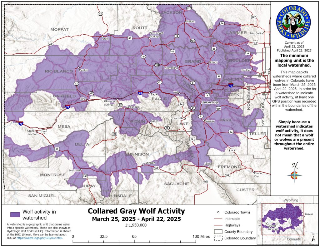
The map uses Colorado watersheds where at least one GPS point from the wolves’ collars has been recorded during the past 30 days. Parks and Wildlife is now tracking 25 wolves with the GPS collars, one less than last month.
An hour before releasing the wolf map, Parks and Wildlife revealed a female wolf died in Rocky Mountain National Park, the third wolf to die this year.
During the last month, one of the male wolves brought from British Columbia died after traveling north into Wyoming. Wolves can be killed at any time without a license in the majority of Wyoming, following the species’ removal from the federal Endangered Species Act in the state in 2017.
This was the second of the Canadian wolves to die in Wyoming. In March, another male wolf was killed by the U.S. Department of Agriculture Wildlife Services after being connected to the death of five sheep in the area.
However, Colorado could soon be adding wolves to its population. Typically, wolves will breed from mid-February through March, with pups born around mid-April and early May.
Parks and Wildlife was not aware of any wolf dens as of Monday, according to Travis Duncan, the agency’s public information officer.
Last year, only two of Colorado’s reintroduced wolves successfully bred. Deemed the Copper Creek Pack, the pair had five pups that are now around 1 year old.
The pack was connected to numerous livestock depredations in Grand County around the time of their denning, leading Parks and Wildlife to capture and place the animals in captivity. The male died shortly after his capture due to injuries sustained from a gunshot wound. The U.S. Fish and Wildlife Service is still investigating the wolf’s potential poaching.
The adult female wolf and the four pups Parks and Wildlife was able to capture were released back into the wild in January. The fifth pup, which escaped capture by the agency, remains in the wild as well.


PHOTOS: Closing day party on Ajax brings end to Aspen’s ski season
The ski season is officially a wrap here in the Roaring Fork Valley, with Sunday’s annual closing day party on Aspen Mountain the winter’s final hurrah.